Tell your friends about this item:
Rand McNally Folded Map: Hawaii State Map Rand Mcnally


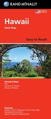
Rand McNally Folded Map: Hawaii State Map
Rand Mcnally
Rand McNally's folded map for Hawaii is a must-have for anyone traveling in or through the state, offering unbeatable accuracy and reliability at a great price. Our trusted cartography shows all U. S., state, and county highways and much more. - Points of interest. - State Park chart. - State mileage chart. - Driving times map. - On-the-road toolbox. - Visitor center information. - Climate data. - State facts & symbols. - Easy-to-use legend. - Detailed indexed. Coverage Area Detailed maps include: Hawaii Volcanoes National Park, Hilo, Honolulu & Vicinity, Wailuku. Product Details: Measures 9.0 x 4.125 and folds out to 25.5 x 36.75.
| Media | Books Paperback Book (Book with soft cover and glued back) |
| Released | March 7, 2022 |
| ISBN13 | 9780528025747 |
| Publishers | RAND MCNALLY |
| Dimensions | 150 × 220 × 10 mm · 158 g |
| Language | English |
More by Rand Mcnally
Show all


![Cover for Rand McNally · A Pocket Atlas of the [world] [cartographic Material]: Presented to the Patrons and Friends of the Chicago & North-Western Ry. Co. With the Compliments of the Passenger Department (Paperback Book) (2021)](https://imusic.b-cdn.net/images/item/original/417/9781015179417.jpg?rand-mcnally-2021-a-pocket-atlas-of-the-world-cartographic-material-presented-to-the-patrons-and-friends-of-the-chicago-north-western-ry-co-with-the-compliments-of-the-passenger-department-paperback-book&class=scaled&v=1649334010)


![Cover for Rand Mcnally · Rand Mcnally Folded Map: Fort Lauderdale Metro Street Map (Paperback Book) [Map edition] (2013)](https://imusic.b-cdn.net/images/item/original/996/9780528007996.jpg?rand-mcnally-2013-rand-mcnally-folded-map-fort-lauderdale-metro-street-map-paperback-book&class=scaled&v=1435855826)
Mere med samme udgiver


See all of Rand Mcnally ( e.g. Paperback Book , Map , Book , Hardcover Book and Spiral Book )