Tell your friends about this item:
Delorme Atlas & Gazetteer Rand McNally


Delorme Atlas & Gazetteer
Rand McNally
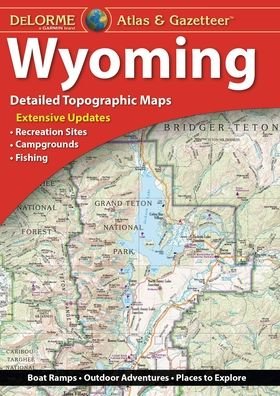
With an incredible wealth of detail, DeLorme's Atlas & Gazetteer is the perfect companion for exploring the Wyoming outdoors. Extensively indexed, full-color topographic maps provide information on everything from cities and towns to historic sites, scenic drives, trailheads, boat ramps and even prime fishing spots.
With a total of 60 map pages, the Atlas & Gazetteer is your most comprehensive navigational guide to Wyoming's backcountry.
Full-color topographic maps provide information on everything from cities and towns to historic sites, scenic drives, recreation areas, trailheads, boat ramps and prime fishing spots.
Extensively indexed.
Handy latitude/longitude overlay grid for each map allows you to navigate with GPS.
Inset maps provided for Yellowstone National Park, major cities as well as all state lands.
Product Details: Wyoming State
Dimensions: 15.5" x 11".
AVAILABLE FOR ALL 50 STATES!
| Media | Books Paperback Book (Book with soft cover and glued back) |
| Released | September 27, 2017 |
| ISBN13 | 9781946494085 |
| Publishers | Delorme Mapping Company |
| Pages | 72 |
| Dimensions | 274 × 389 × 8 mm · 408 g |
| Language | English |
More by Rand McNally
Show all


![Cover for Rand McNally · A Pocket Atlas of the [world] [cartographic Material]: Presented to the Patrons and Friends of the Chicago & North-Western Ry. Co. With the Compliments of the Passenger Department (Paperback Book) (2021)](https://imusic.b-cdn.net/images/item/original/417/9781015179417.jpg?rand-mcnally-2021-a-pocket-atlas-of-the-world-cartographic-material-presented-to-the-patrons-and-friends-of-the-chicago-north-western-ry-co-with-the-compliments-of-the-passenger-department-paperback-book&class=scaled&v=1649334010)


![Cover for Rand Mcnally · Rand Mcnally Providence Street Map (Paperback Book) [Map edition] (2020)](https://imusic.b-cdn.net/images/item/original/153/9780528008153.jpg?rand-mcnally-2020-rand-mcnally-providence-street-map-paperback-book&class=scaled&v=1512788431)
Mere med samme udgiver
More from this series
See all of Rand McNally ( e.g. Paperback Book , Map , Book , Hardcover Book and Spiral Book )